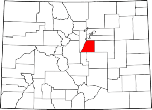
The team’s primary area of responsibility is Douglas County, Colorado, which is located near the center of the state. Douglas County’s urban areas are part of the Denver metropolitan region and contain several large suburbs. The southwest section of the county contains a large section of Pike National Forest. This mixture of wild, urban, and suburban centers means DCSAR must train for all search and rescue scenarios.
State Parks
- Chatfield This state park in the northwest section of the county offers hiking, camping, boating, fishing, and many other outdoor activities.
- Castlewood Canyon Castlewood Canyon’s scenic views provide a breathtaking backdrop to activities such as hiking, birding, rock-climbing and wildlife watching. Numerous educational activities are also offered.
- Roxborough This park is a National Landmark for a reason; numerous easy hiking trails enable the enjoyment of intricately beautiful red rock formations, just a short drive from Denver.
Recreational Areas
- Douglas County Parks, Trails, and Open Spaces “Douglas County Division of Open Space and Natural Resources seeks to enhance the quality of life for residents by protecting wildlife habitat, natural resources, historic sites, scenic views and Douglas County’s rural heritage while providing a wide range of compatible outdoor recreation and educational opportunities.”
- Rampart Range This is a popular area for off-highway vehicle enthusiasts. Numerous trails allow OHV uses; this area also provides access to the Devil’s Head watchtower.
- Waterton Canyon The road to the Strontia Springs reservoir provides hiking, biking, and fishing activities. The Colorado Trail and Roxborough State Park trail systems can also be accessed from this area. Good location for wildlife viewing as numerous bighorn sheep live in the area.
- Devil’s Head This landmark is the last full-time forest fire lookout in Colorado. It receives several thousand visitors per year.
- Pike National Forest (South Platte Ranger District)The South Platte Ranger District covers 450,000 acres of Pike and San Isabel National Forests, and the Cimarron and Comanche National Grasslands.
Trails
- Highlands Ranch Open Space trails Fifty-plus miles of paved and crusher fines trails connecting parks and open space in the community of Highlands Ranch
- Cherry Creek Regional Trail Twenty-four-mile paved trail follows Cherry Creek from Castlewood Canyon in the south to Cherry Creek State Park in the north
- High Line Canal This scenic, natural-surface trail follows the High Line Canal from Waterton Canyon north through the communities of Highlands Ranch, Littleton, Englewood, and Denver
- Colorado Trail The 500-mile trail crosses the state of Colorado from Denver to Durango. Segment one begins at Waterton Canyon and much of its length passes through Douglas County.
Towns and Communities
- Highlands Ranch Parks and Open Space
- Parker Parks information
- Lone Tree Parks and Recreation
- Castle Pines North Open Space Parks
- Castle Rock Parks, Open Space, and Trails
- Sedalia
- Larkspur
- Franktown